
BU YAZIDA NELER VAR?
Lycian Way is a long-distance trail in southwestern Turkey around part of the coast of ancient Lycia Federation. Total trail is 540 km in length and starts from Hisarönü (Fethiye) to Geyikbayırı (Antalya).
Olympos is located in the middle of Lycian Way. Departing from Olympos, one can hike several parts of Lycian Way in daily walks. Some of these daily trails are below. To download GPX files properly right click to links and select “Save link as”.
Beycik-Tahtalı
Start: Beycik Village (348 m)
End: Mount Olympos/Tahtalı Peak (2315 m)
Transportation: Start point (Beycik) is 25 km from Kunduz Kamp. You can go by car or taxi. Trail ends at cable car station at the peak. You can go down by cable car. And from lower station, again take a taxi to the camp (35 km) or to where you left your car.
Distance: 8.9 km
Ascent: +1480 m
Time: 6-7 hours
Trail: All ascent, some steep climbs. Very hot and sunny in summer. Get enough water before starting the trail. Follow red-white marks of Lycian Way, don’t enter trails with cross mark. End of the trail, you can take cable car to go down where you can reward yourself with beautiful views.
Olympos-Adrasan
Start: Olympos
End: Adrasan beach
Transportation: Starting point (Olympos river crossing) is in walking distance from Kunduz Kamp, and it takes 20 minutes on foot. End at Adrasan beach. For return you can take a taxi to the camp (10 km).
Distance: 12.8 km
Ascent/Descent: +780 m/-790 m
Time: 6-7 hours
Trail: This forest trail starts and ends at sea level, and passes Mount Musa, where you can see another part of Olympos ruins. Follow red-white marks of Lycian Way, don’t enter trails with cross mark. Just before the end at Adrasan beach, don’t forget to visit Adrasan Castle.
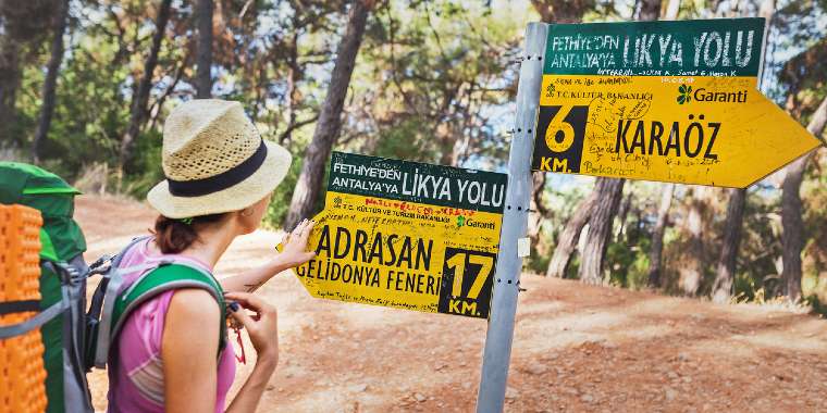
Adrasan-Gelidonya-Karaöz
Start: Adrasan beach
End: Karaöz Village
Transportation: Starting point of this trail is at the end of Adrasan beach, which is 13 km from Kunduz Kamp, accessible by car or taxi. After the hike, you can take a taxi from Karaöz to Kunduz Kamp (17 km), or to Adrasan beach if you left your car there.
Distance: 20.8 km
Ascent/Descent: +780 m/-780 m
Time: 9 hours
Trail: Long route that needs to be started very early in the morning. Follow red-white marks of Lycian Way until Korsan Koyu (bay), don’t enter trails with cross mark. Contains beautiful views opposite to Suluada and from Gelidonya lighthouse. After Korsan Bay, follow the forest trail to Karaöz village center.
Korsan Koyu-Gelidonya
Start: Korsan Bay
End: Korsan Bay
Transportation: Start and end point of this trail is Korsan Koyu (bay near Karaöz), which is 20 km from Kunduz Kamp. You can go and return by car or taxi.
Distance: 10.6 km
Ascent/Descent: +300 m/-300 m
Time: 4 hours
Trail: This short trail is an alternative to the previous one and can be planned as a swim&hike activity. Visiting Korsan Bay (or for a more quiet one: the unnamed bay next to Furkan camping), swimming there, then start hiking up to Gelidonya lighthouse, watching beautiful views of five islands and returning back same way.
Ulupınar-Chimera-Çıralı
Start: Ulupınar (main road)
End: Çıralı
Transportation: From Olympos go up to main road by shuttle minibus or taxi. Trail starts under Şelale Restaurant. Ends at Çıralı town center where you can easily access beach and walk to Olympos and then to the camp.
Distance: 8.7 km
Ascent/Descent: +180 m/-490 m
Time: 3-4 hours
Trail: A relatively short trail but need to spend some time in Chimera (eternal flames). Alternatively the reverse of the trail can also be planned (start: Çıralı end: Ulupınar) with a bit more climb.